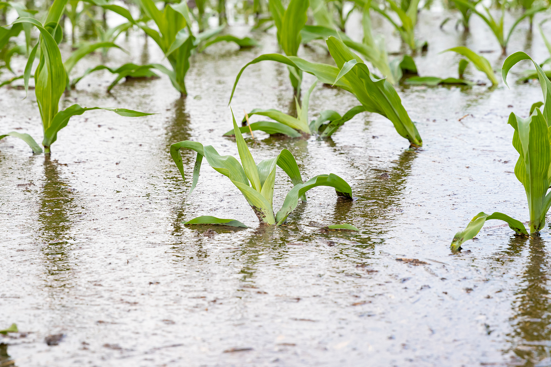
A waterlogged corn field
Summary
An exchange took place Thursday 14th of April 2022 between The Horn of Africa Regional Environment Centre and Network (HoAREC&N) and Slovak experts on flood mitigation and watershed regeneration. The solutions discussed include practical means of watershed regeneration and flood mitigation involving communities. In practice, it means manually building smaller dams or lines of stones and sticks from available local material.
Great water challenges in the Horn of Africa
John: Our water challenges include droughts and floods. Other issues are deforestation, land degradation also building of roads that affect water flows. Horn of Africa is known for its droughts but a great challenge is that there are also serious floods that displace communities. For example in South Sudan, flooding was displacing a lot of people in Nov 2021. They had to scoop water from their premises and fields were flooded. A lot of the time in Oct-Nov every year the communities spend it in water. Floods often flow faster in dry areas and destroy crops and erode soils with malnutrition and displacement as a result. There is water, but it can not be used for drinking as it is too dirty. To address these challenges, catchment regeneration is something that HoAREC&N is working on, using a landscape approach. We want to see how the flood water be used during droughts.
The entire area is suffering from floods, and yet no one is talking about integrated development. A lot of focus is on early warning systems, risk assessment, and resilient infrastructure including expanding construction of large-scale irrigation systems, and establishing mega dams. But smaller, simpler solutions, where communities can be engaged, connectivity between upstream and downstream, is not articulated in the national documents.
Droughts and floods are tightly linked
Peter: It is happening all over the world. People don’t understand that drought and floods are systems. I am sad seeing this [John has showed photos of displaced communities]. When I worked in Pakistan they built dams in the Himalaya saying it will produce energy and control the flood situation. It helped nothing, and perhaps doing more harm. You know, concrete is very rarely a solution for nature. The water that is causing trouble would be a blessing in different times.
John: Understanding the dynamics of what happens in the landscape and why these floods occur is key.
Peter: I am a hydrologist and modeler so I would like to start to describe what happens when it rains and the water starts flowing in the catchment. The typical hydrograph - a curve describing the flood passing through your place, looks like this: A steep curve going up, which peaks and slowly recesses. The whole area under the curve is the water volume passing. If you have the same rainfall but the catchment is able to slow down the flow by forest, and vegetation – the peak will take more time –and be less high with the recessing line longer.

Slow down the flow
Slowing the flow recharges the groundwater and reversing desertification bringing back vegetation and reducing erosion of the soil.
Peter: You do not need big dams, but turn your soil and landscape into your biggest water reservoir. Change the landscape and soil to be like a sponge to soak in the water. This is our approach which we call the new water paradigm. Look for places where water is visibly flowing - with spots of erosion - and you use local material and do it manually, because it is not big things, and these dams do not need to be perfect – it is stones on top of each other. But they do the important work: instead of water flashing slopes it soaks in. In the moment water is present, life catches on. Grass starts grow. You cannot do it in a week. It takes two to three seasons but it is not expensive or hard to do. I believe this is the way to go in many many cases.
Peter: Michal Kravčík from our organization People and Water trained a lot of people in building these measures that slow down the water. But training can only go so far. I am pretty sure Africa has its own challenges and can only be solved by African people.
Go Top down
Peter: A practical insight is that we must start with measures top down in the catchment. If you start to do something down in the village - your measures will be flushed away by the next flood. You need to start doing the measures from the top and then you see the result further down in the catchment. Springs that were dried out come to life again. Floods become less extreme. Slowing the flow high up in the watershed is key to recharge springs and reduce flooding downstream.
Capture the positional energy of water (capture it in the catchment)
Peter: Water flowing from a high position high up in the catchment, have a lot of positional energy that turns into kinetic (movement) energy. If you get water into stream the positional energy gets turned into kinetic energy and this acts to create erosion and other more forceful impact on the landscape. We need to use this energy better by capturing the water higher up in the watershed. For example we spend energy on irrigating fields, but this water was already falling on mountains and slopes, and bringing of water up requires a lot of energy, so this is energy we already had and lost.
Data needed
Peter: We need hydro met data (mainly rainfall data) from local hydro met stations. Many are operational for nearly 100 years. Many have water level and flow measurements – with about 60-70 years of measurement history. Data sets on rainfall is usually available within states. If they are a member of WMO they are working to unify that data.
Peter: We also need geological maps to understand what is underground. You have some places where you have your saturated layer of groundwater 100-200 m under the surface. You can add water to it but you could not expect your plants to take advantage and especially on those mountain areas you have an impervious layer and you know that once you soak enough water in a year or two your grass is going to start growing there.
Engage with local people
Peter: What we learnt and believe in is that you need to start by talking with the local people. We will not get any result if we do not find local people who will understand and help us and continue the work.
Stone contour lines/infiltration swales
Peter: All kinds of structures are useful for supporting the water to be infiltrated into the ground. You can use agricultural residues, throw in pieces of wood, stones forming contour lines. Contour lines is a very simple method where you put stones on elevated places and create a 10 cm edge, then five meters uphill you create another line in parallel. This stops runoff which instead soaks into he ground. There are many solutions and it is important to do some.
John: We are working with communities that build earth dams – where water flows from the highlands and collect in these dams and the community can use the water before it dries up. They also used to capture water from hilly areas. Also at times stone bands are applied where water is captured, and help water infiltrate in the ground, in particular in agricultural areas, that use that water for planting and cereal grain etc. But it is not used in all areas. In highland areas of Ethiopia they use these to control flows.
Peter: This is what I was hoping for that people could learn from their neighbors.
Exchange for the future
HoAREC&N expressed a wish for bringing the Slovak experts for an exchange to the field and bringing other regional stakeholders onboard as part of the ongoing partnership agreement with GCA.
John: We need a sustained engagement. When this conversation has started. Face to face engagement. When we bring together the actors the expertise of Peter and Michal can be useful.
The Slovak knowledge on how forest influences the local hydrological system resonates also with the case of Sudd wetlands, whose evaporation is also believed to have effect on a green belt in South Sudan.
The WAC will be organizing focus group discussions on dryland challenges in the autumn 2022. Check out the WAC Community Calendar.


Trending Discussions
From around the site...
“Absolutely interested! I'll connect via email to discuss reviewing and enhancing the Economic Analysis of Climate...”
Adaptation-related events at COP28 (all available to follow/stream online)
“Please check out these adaptation-related events taking place at COP28 - all available online (some in person too if...”
Shining a light for biodiversity – four perspectives to the life that sustains us. Four hybrid sessions.
“30 November to 19 December 2023 - Four Sessions Introduction The SDC Cluster Green is happy to invite you to the...”